As stated in The Complete On-Board Celestial Navigator the azimuth tables have
been designed to produce a value of azimuth which is compatible with the sight
reduction procedure described in the book. An accuracy of one or two degrees
will be sufficient when the intercept is short, which will be expected when the
DR position is used.
If the variables of Declination, Local Hour Angle and Latitude are used to
interpolate the tables, the aforementioned accuracy is achieved. However, the
process can be considerably shortened if the variables are rounded off to the
nearest degree before using the tables. The accuracy of this latter process is
investigated here using the same principles that were adopted to analyse the
sight reduction tables which is described previously in Detailed description.
This technique of assessing the accuracy of look-up tables was suggested by Dr
B D Yallop, former Director of HM Nautical Almanac Office.
The azimuth tables have been investigated using a computer program that
simulates a human operator selecting, combining and extracting values from the
tables over the following ranges of the principle parameters:
Each parameter takes on values at a quarter of a degree intervals and all
combinations of the three parameters were used in the analysis. Theoretically
there should be
(180 x 4 +1) x (70 x 4 +1) x (180 x 4 +1) = 146,075,321
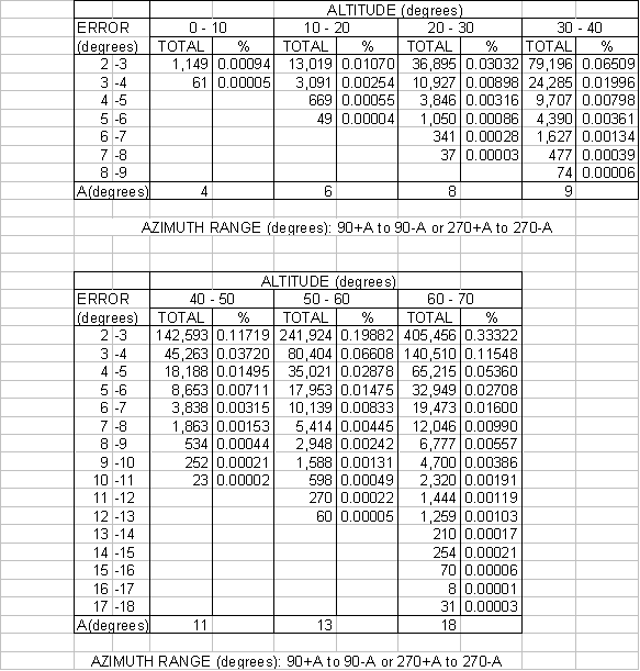
possible cases to examine, but some combinations of the parameters will not form a spherical triangle and were therefore excluded. The remaining 121,677,000 cases form the sample to be tested. Such a sample size should be sufficient to assess the performance of the tables. The differences, called errors, between the azimuths calculated accurately and those derived from the solution using the tables were compiled and the results of that investigation are as follows:
It will be seen that the preponderance of acceptable errors, i.e. less than two
degrees, comprises 98.8% of the sample. Very large errors i.e. greater than ten
degrees occur in only 0.005% of the sample. An error in excess of ten degrees up
to a maximum of less than 18 degrees is extremely rare.
The question now arises; under what circumstances do we find errors greater than
two degrees? The answer to this question is not obvious. Further analysis of
the previous results is given in the following table, which is in two parts and
shows that (a) these errors increase in number and size with an increase in
altitude and (b) at low altitudes these errors are small and occur close to the
east-west line (prime vertical). The proximity to the prime vertical can be
found from the value of the quantity “A” given at the foot of the table. For
example if an observation was made at an altitude of 15 degrees the maximum
error that could occur would be less than six degrees in an azimuth range of 84
– 96 or 264 – 276 degrees.
It should be noted that even though an observation may have been made at high
altitude and close to the prime vertical the size of the error is also dependent
on the degree of rounding off that has been made to the principal parameters
before using the azimuth tables.
An ambiguity in the value of azimuth may arise when the body is near the prime
vertical.. This is because an angle near 90º º or 270º, when derived from its
sine, will have two possible values
e.g. sin.89º =
sin.91º or
sin.267º =
sin.273º. In most cases in practice, it will be obvious which of the two values to
choose e.g. from prediction, compass bearing etc. If may be possible to remove
this ambiguity as follows, (a) if the declination has the opposite name to the
latitude, the body will lie in the southern sky in northern latitudes, and in
the northern sky in south latitudes, (b) if the declination has the same name
and is greater than the latitude the body will lie in the northern sky in north
latitudes and in the southern sky in south latitudes. If the ambiguity has still
not been resolved this will be found by comparing the values of the observed
altitude with that when the body lies on the prime vertical. The tables
themselves are used to determine the altitude of the body when on the prime
vertical. A simple summary of the situation is given in the diagrams on page 19
of TCO-BCN.
The previous explanation and analysis of the azimuth tables may give the
impression that they are difficult to use or inaccurate. From my experience,
both as a practicing navigator and teacher, this has not been the case. In my
opinion they are simple to use and inaccuracies will only occur in rare
circumstances. These circumstances are not easy to quantify succinctly. However,
as a guide, the user should interpolate the tables if rounding off has been
substantial, the observed altitude is high or the body lies within about twenty
degrees of the prime vertical. Alternatively use the Weir diagrams provided.
Since the publication of The Complete On-Board Celestial Navigator in 1988 I
have only received one complaint and that was illustrated by a single example
which used rounding off values of 29, 31 and 31 minutes of arc in the three
principal parameters at an altitude of over 61 degrees and within nearly 15
degrees of the prime vertical. Such an extreme case is most unlikely to occur.
Constructive, objective criticism of the table as a whole are welcome,
particularly if supported by impartial analysis and examples taken from
practical experience.